Oil & Gas: Validation Of Emission Quantification Performance with the National Physical Laboratory
The adoption of new technologies into heavily regulated industries such as the oil and gas industry is intrinsically linked to rigorous validation of their performance. To this end, QLM has sought to carry out field testing of equipment against known, controlled releases of CH₄, both with recognised measurement institutes and industrial partners. QLM’s longest standing partner in these field tests is the National Physical Laboratory (NPL), the UK’s national measurement institute, who maintain their own controlled release facilities for the validation of LDAR techniques. A campaign of field trials was undertaken at NPL, with the prototype Quantum Gas Lidar was used to image controlled releases of CH₄ in an outdoor setting.
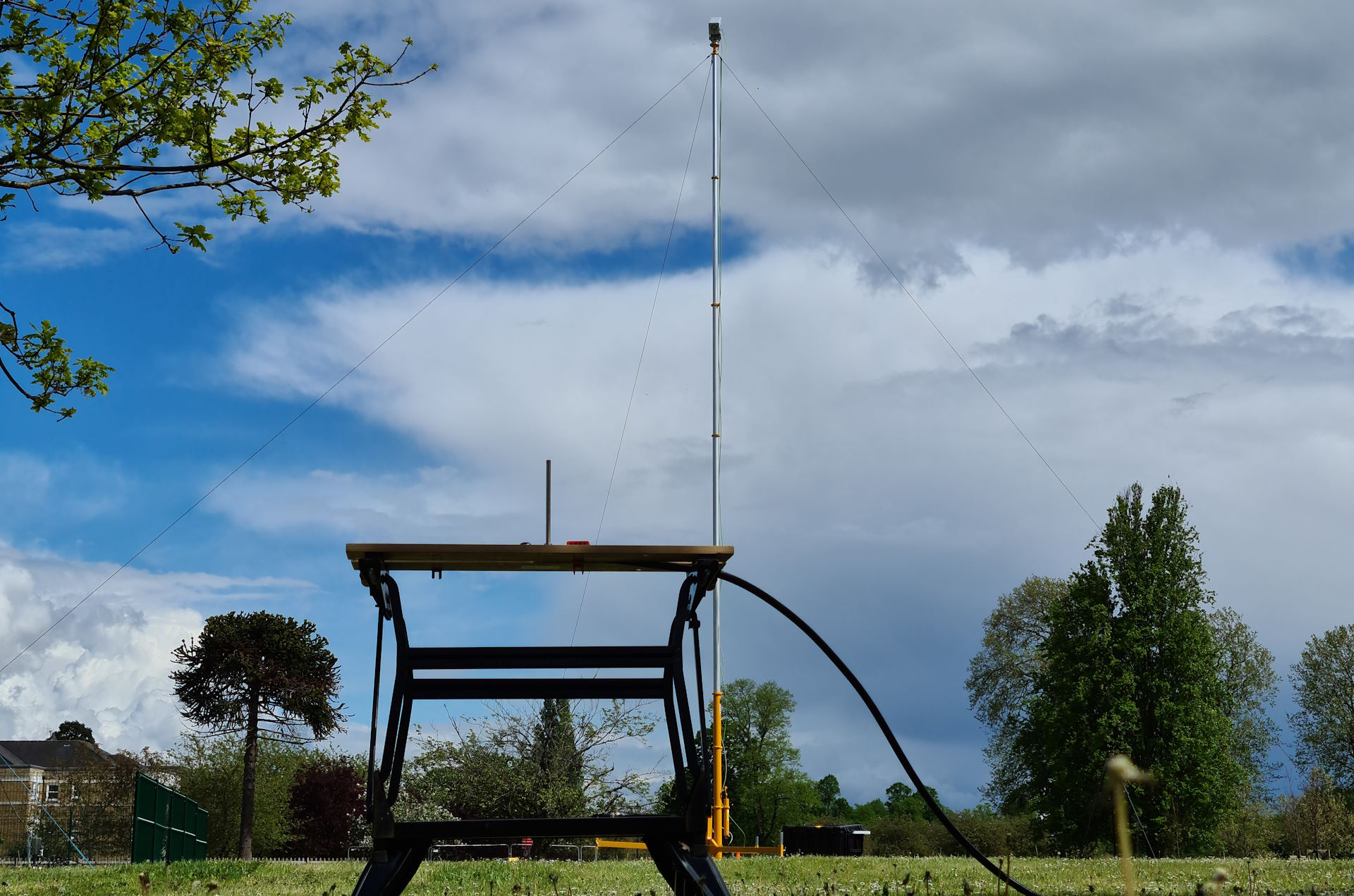
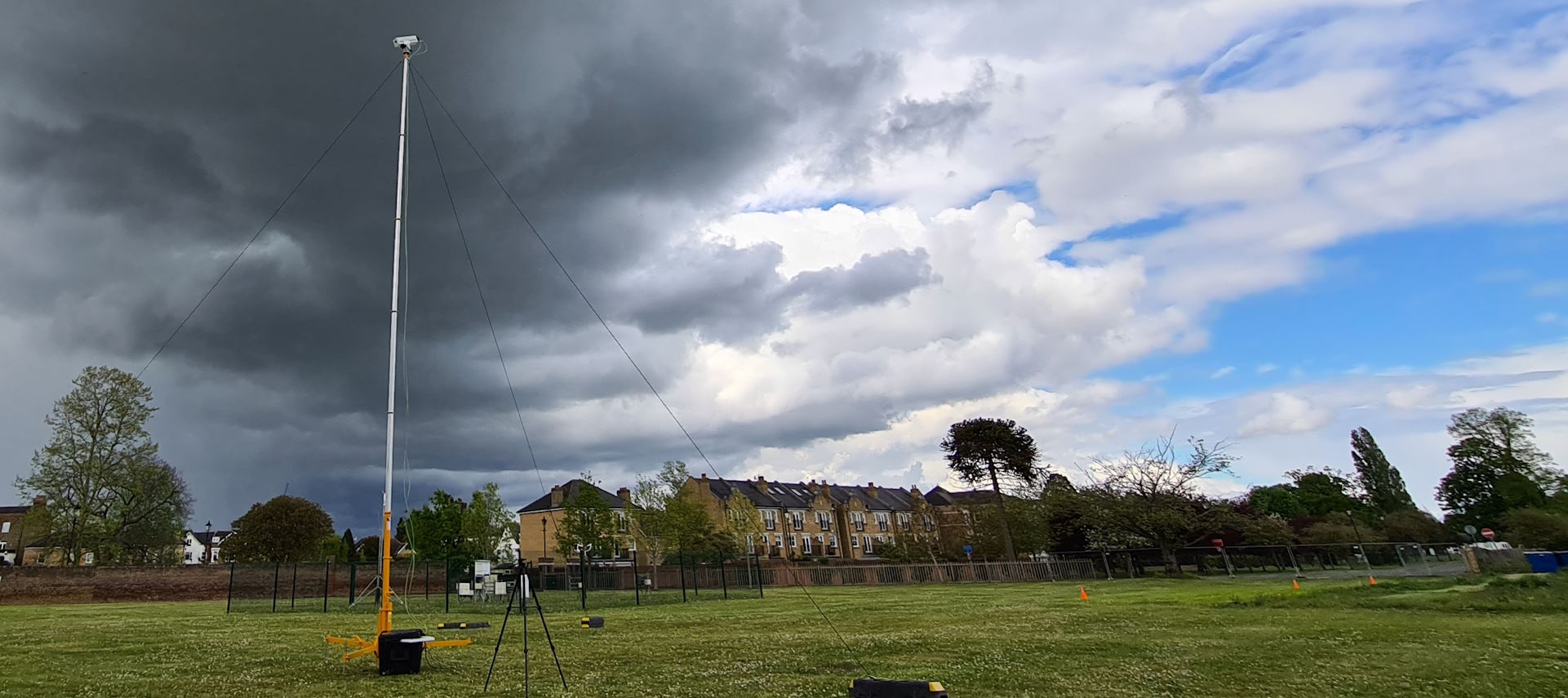
The prototype Quantum Gas Lidar monitoring a controlled emission
Measurements were made at a range of distances and release rates, in varying environmental conditions (both natural and artificial). NPL's own controlled release system¹ was used to control the release rate of CH₄. Figure 1a-b (below) illustrates the experimental setup for varied sensor range and flow rate measurements.
Varying Release Rate and Range
The lidar was placed at several distances from a mounted release tube connected to a mass flow controller. CH4 was nominally released at between 0.012 g/s and 0.835 g/s (the mass flow controller used units of litres per minute, and these values corresponded to 1 L/min to 70 L/min). Measurements were taken from distances between 16 m and 90 m from the CH₄ release point with the sensor directed horizontally across a field and a backdrop of trees and a brick wall for laser scattering. The backdrop was around 15 m behind the CH₄ release point.
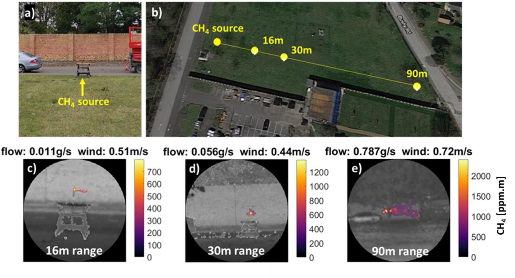
Figure 1: Calibrated CH₄ leak imaging. CH₄ plumes of varying sizes were created with a calibrated piped CH₄ supply and measured at varying distances and environmental wind conditions. The experimental setup is shown in a) and b). Images c)-e) show examples of ppm.m plume images overlaid on the signal level image.
Typical results from measurements in this configuration are shown in Figure 1c-e. Each image corresponds to a measurement time of approximately one hundred seconds (i.e. 10,000 of the 10 ms duration CH₄ readings). Releases of as low as 0.012 g/s were imaged from the shorter 16 m range. However, at longer ranges the relatively small solid angle occupied by the small leak made the probability of intersection with the sensor beam too low for detection within a reasonable timeframe. Releases of 0.056 g/s were imaged clearly from up to 30 m range, while the 0.835 g/s was easily detectable from 90 m. Based on the relative size and high ppm.m values detected in the 0.835 g/s release we estimate that this would be detectable at up to 200 m range, though due to the limited size of the field this was not verified experimentally.
Larger CH₄ releases were easily detectable at the longer ranges, while shorter range measurements were able to detect and visualise even the smallest releases. The limitation in detection of small leaks at long range was caused by the spatial resolution of the laser system, rather than a lack of sensitivity to low ppm.m levels, or range of the optical transceiver system. It is expected that the detection of small leaks (0.01 g/s) at long ranges (hundreds of meters) could be achieved if the laser scanner directly intersected the plume.
Varying Environmental Conditions
An important factor in imaging and quantifying gas emissions is the speed of the wind. Variable wind speeds were created using an artificial source in the form of a large fan, illustrated in Figure 2a.
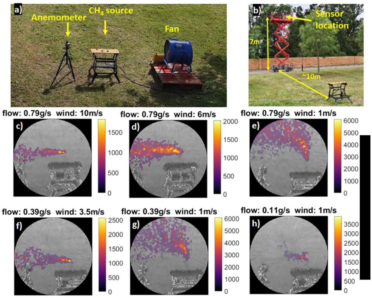
Figure 2: CH₄ leak imaging with controlled wind conditions. CH₄ plumes of varying sizes were measured at varying wind speeds. The experimental setup using a large fan to vary winds speed at the plume is shown in a) and b). Images c)-h) show example results for various combinations of wind speed and CH₄ flow rate.
An anemometer was positioned in the path of the fan, close to the CH₄ source, to monitor the local air flow speed. This setup allowed simulated wind to be applied to the CH₄ source with speeds of 1 m/s to around 10 m/s. On this occasion, the sensor was deployed at height using a mobile elevated work platform (MEWP), looking down over a short distance perpendicular to the flow of wind generated by the fan as shown in Figure 2b. The background of the image was the grassy field around 13 m from the sensor. Release rates and artificial wind speeds were varied to evaluate the limit at which wind speed reduced the effectiveness of the measurement.
The variation in wind produced an expected variation in the shape of the plume, clearly imaged by the TDLidar sensor. High wind velocity caused narrow and straight plumes, while lower wind velocity produced border plumes with a gentle curve towards the wind direction (Figure 2c-h). At higher wind velocities, some smaller releases are sufficiently diluted by the air flow to make them more difficult for the lidar to detect, resulting in less obvious visualisation and higher uncertainty in the flow rate calculation. It should be noted, however, that the artificially induced wind was constant, which is unlikely to be true of conditions experienced in real-world environments. It seems likely that capability to image the way the plume changes shape and density over time could provide information about the local wind speed² which would be useful for flow rate estimation.
Flow rates were estimated using the simple mass balance algorithm applied to the entire data set acquired during the trial. An anemometer positioned at roughly 1 m height was used to record the wind speed with one-minute time resolution which was then used in the mass balance calculation.
Measurement Accuracy
The flow rate estimation results for all tests at NPL using the TDLidar sensor are shown in Figure 3. This includes results from measurements with high (artificial) wind and long range.
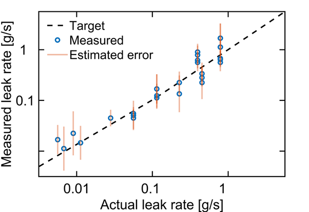
Figure 3: CH₄ leak flow rate measurement accuracy. Comparison of calculated leak flow rate and calibrated leak rate for all measurements during the NPL field trial.
The correlation between calculated leak flow rate and actual leak flow rate is strong considering the simple flow algorithm and variety of wind speeds and ranges. Across the whole set there is an average percentage error of around 50 % between the estimate and the true flow value. We believe this can be significantly improved as we continue to refine the sensor performance and our flow rate calculations, but This continues to improve with the development of the lidar, but even these results indicate very good potential for accuracy at the level needed for effective industrial monitoring.
[1] T. Gardiner, J. Helmore, F. Innocenti, and R. Robinson, “Field Validation of Remote Sensing Methane Emission Measurements,” Remote Sens., vol. 9, no. 9, p. 956, Sep. 2017, doi: 10.3390/rs9090956.
[2] S. Jongaramrungruang et al., “Towards accurate methane point-source quantification from high-resolution 2-D plume imagery,” Atmos. Meas. Tech., vol. 12, no. 12, pp. 6667–6681, Dec. 2019, doi: 10.5194/amt-12-6667-2019.